
Introduction
A map of Germany is more than just a visual representation of a European country—it is a gateway to understanding one of the most influential nations in the world. Whether you are a traveler planning your next adventure, a student studying geography, or a business professional exploring market opportunities, having a clear and detailed map is essential. Germany’s central position in Europe makes it a hub of culture, commerce, and connectivity, and its map reflects a rich blend of natural landscapes, historical regions, and modern infrastructure.
Maps of Germany come in many forms, each serving a unique purpose. From political maps that outline federal states to physical maps that highlight mountains and rivers, each type provides valuable insights. With the rise of digital tools, interactive maps now allow users to explore cities, routes, and landmarks in real time. Understanding how to read and use these maps can significantly enhance your knowledge and planning capabilities.
In this comprehensive guide, we will explore Germany’s geography, political divisions, major cities, and different types of maps. We will also look at how maps have evolved over time and why they are important in education, travel, and business. By the end of this article, you will have a deep understanding of how to effectively use a map of Germany for various purposes.
Overview of Germany’s Geography
Germany is located in the heart of Europe, making it one of the most strategically positioned countries on the continent. It shares borders with nine countries, including France, Poland, Austria, and the Netherlands. This central location has historically made Germany a crossroads for trade, culture, and political influence. A map of Germany clearly illustrates its connectivity, showing how major routes and neighboring nations are linked through its territory.
The physical landscape of Germany is incredibly diverse. In the south, the Bavarian Alps dominate the terrain with stunning mountain ranges, while the central region features dense forests such as the Black Forest. Northern Germany, on the other hand, is characterized by flat plains and coastal areas along the North Sea and Baltic Sea. Major rivers like the Rhine, Danube, and Elbe flow across the country, playing a crucial role in transportation and economic development.
Germany’s climate varies depending on the region, which is also reflected in its maps. Coastal areas experience a maritime climate with mild temperatures and higher humidity, while inland regions have a more continental climate with colder winters and warmer summers. Understanding these geographical and climatic differences through a map of Germany helps travelers and researchers make informed decisions.
Political Map of Germany
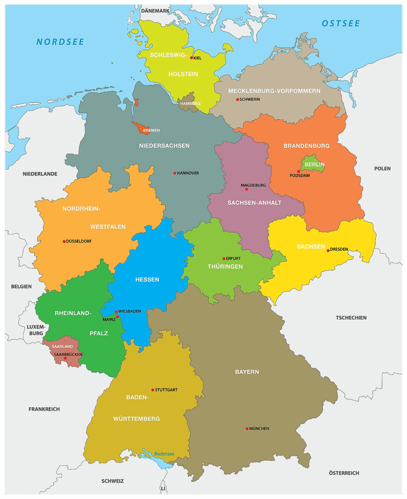
The political map of Germany reveals its federal structure, consisting of 16 states known as Bundesländer. Each state has its own government, contributing to Germany’s decentralized political system. This structure is clearly outlined in political maps, which divide the country into distinct regions with defined boundaries. These maps are particularly useful for understanding governance, regional policies, and administrative organization.
Each German state has a capital city that serves as its administrative center. For example, Bavaria’s capital is Munich, while Berlin serves as both a city and a state. Political maps highlight these capitals, making it easier to identify key locations across the country. These maps are widely used in education and research to provide a clear understanding of Germany’s political landscape.
Administrative divisions go beyond states, extending into districts and municipalities. These smaller units are essential for local governance and public services. A detailed map of Germany often includes these divisions, offering a granular view of how the country is organized. Such maps are particularly useful for businesses, policymakers, and logistics companies that need precise regional information.
Major Cities on the Map of Germany
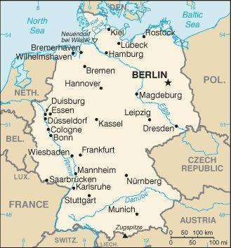
Germany’s major cities play a vital role in shaping its identity, and their locations are prominently displayed on any map of Germany. Berlin, the capital city, is located in the northeastern part of the country and serves as a political and cultural hub. Its position on the map highlights its accessibility and importance as a center of governance and history.
Other major cities such as Hamburg, Munich, Frankfurt, and Cologne are key economic and cultural centers. Hamburg, located in the north, is a major port city, while Munich in the south is known for its rich traditions and strong economy. Frankfurt, situated in central Germany, is a global financial hub, and Cologne is famous for its historical landmarks. Maps help users visualize the distribution of these cities and their connections.
Tourist cities like Heidelberg, Dresden, and Stuttgart also feature prominently on maps. These locations attract millions of visitors each year, and maps are essential tools for planning trips. By studying a map of Germany, travelers can identify routes, distances, and nearby attractions, making their journeys more efficient and enjoyable.
Types of Maps of Germany
There are several types of maps of Germany, each designed to serve a specific purpose. Physical maps focus on natural features such as mountains, rivers, and terrain. These maps are ideal for understanding the country’s geography and environmental characteristics. They use colors and shading to represent elevation and landscape variations.
Political maps, on the other hand, emphasize boundaries, states, and cities. They are widely used in schools and offices to provide a clear overview of Germany’s administrative structure. These maps are essential for understanding how the country is divided and governed.
Road and transportation maps are particularly useful for travelers. They show highways, rail networks, and airports, helping users plan routes and navigate efficiently. Tourist maps go a step further by highlighting attractions, landmarks, and cultural sites. In today’s digital age, interactive maps have become increasingly popular, offering real-time navigation and detailed information at the click of a button.
How to Read and Use a Map of Germany
Reading a map of Germany effectively requires an understanding of basic elements such as legends, symbols, and scale. The legend explains what different colors and icons represent, while the scale helps users determine distances. These components are essential for interpreting the map accurately.
Coordinates, including latitude and longitude, are another important aspect of map reading. They allow users to pinpoint exact locations and measure distances between points. This is particularly useful for navigation and geographic studies.
Maps have practical applications in everyday life. Travelers use them to plan routes, students use them for learning, and businesses rely on them for logistics and market analysis. By mastering the skill of reading a map, users can unlock a wealth of information and make more informed decisions.
Conclusion
A map of Germany is a powerful tool that offers insights into the country’s geography, politics, and culture. From understanding natural landscapes to navigating cities and planning travel routes, maps play an essential role in various aspects of life. With the availability of different types of maps, users can choose the one that best suits their needs.
As technology continues to evolve, digital and interactive maps are becoming increasingly important. They provide real-time updates and detailed information, making navigation easier than ever before. Whether you are exploring Germany for the first time or conducting in-depth research, a well-designed map is your ultimate guide.
FAQs
1. What is the most useful map of Germany for travel?
Road and tourist maps are the most helpful for travelers as they show routes, attractions, and transportation networks.
2. How many states are included in Germany’s map?
Germany is divided into 16 federal states, each with its own capital.
3. What are the key geographical features on a map of Germany?
Major features include the Alps, the Rhine River, the Black Forest, and northern plains.
4. Are digital maps of Germany better than physical maps?
Digital maps offer real-time updates and navigation, while physical maps are useful for offline use and broader overviews.
5. Why is Germany’s location important on a map?
Its central position in Europe makes it a key hub for trade, travel, and cultural exchange.


Leave a Reply